Exactly one year ago, this meteorologist experienced one of the dreams that probably all meteorologist have: being in the middle of a polar low in Svalbard. It was one of the most extreme weather situations I have ever experienced. It was definitely the strongest snow storm I have been in, and probably even the highest wind speeds I have ever faced. In this blog post, we look back on this extreme and interesting weather event. A video of the event is included.
What is a polar low?
Before we dive deeper into this weather situation, let us discuss a little bit about the terminology: A polar low is a small cyclone that forms in cold air masses. It is sometimes referred to as an arctic hurricane. Polar lows distinguish themselves from ordinary extratropical cyclones by their relatively small size, their small but powerful windfield and their formation mechanisms.
The formation of polar lows generally happens when very cold (upper) air moves over a relatively warm sea surface, which causes convection. Cumulonimbus (Cb) clouds form and often cause intense precipitation (snowfall). When the Cb’s clusters and starts to form a low pressure system (just like in a tropical cyclone), a polar low is born. Despite the extreme (hurricane force!) winds that can occur during a polar low, they are less strong than tropical cyclones. They are smaller, the cloud top is much lower and overall the systems contain less energy and less precipitation. Polar lows are also a bit less symmetric than tropical cyclones.
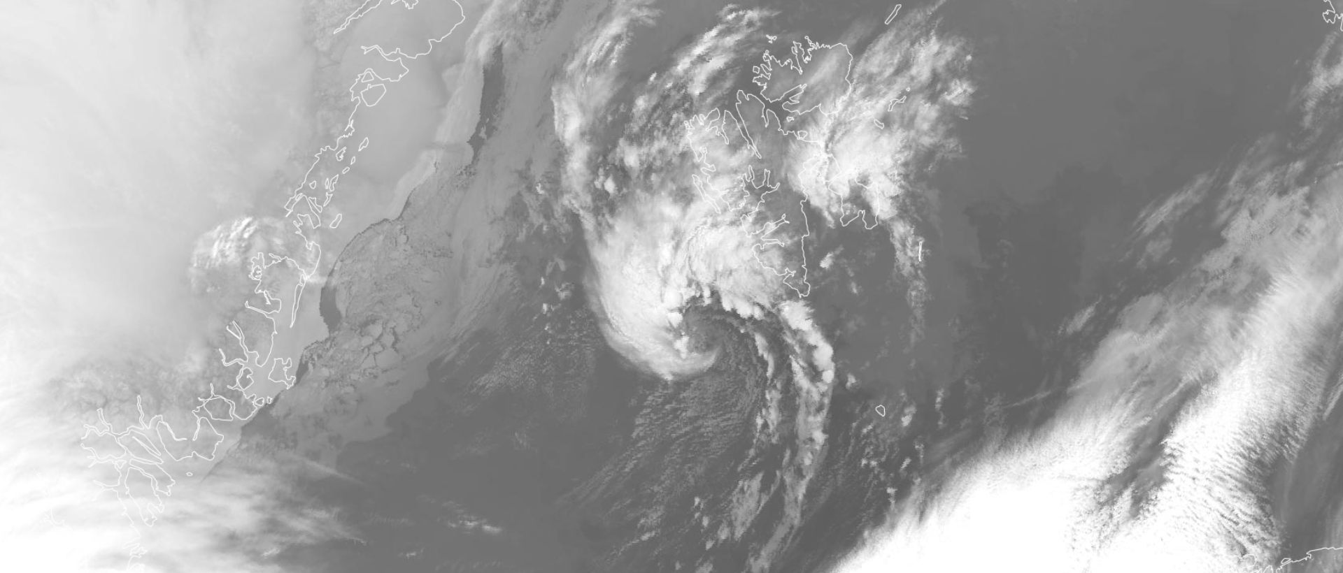
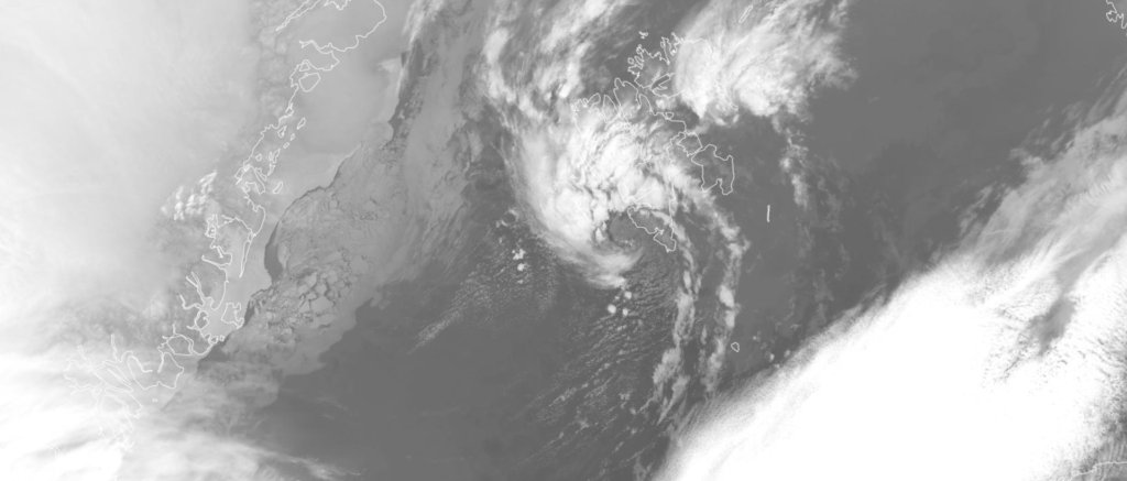
On satellite images, polar lows often can be identified by a comma shaped cloud formation. No clear fronts are visible, and generally the low has a (partly) cloud free eye and is surrounded by Cb clouds.
Visiting Svalbard in March 2022
Now we have the terminology straight, let’s get back to the weather situation. After having been to Svalbard twice, once in the fall semester and once in summer, in 2022 it was finally possible to go there in the springtime. When arriving early March the weather was, despite temperatures being subzero, relatively mild for the time of year (normal March temperature in Svalbard is around -12.0; read more about Longyearbyen’s climate here). However, halfway through the month, about a week after I arrived, the temperatures rose well above 0 degrees. Accompanied by a lot of rain, the mild temperatures caused lots of snow to disappear.
The mild weather worried me a bit, as it made going on snow mobile trips (my main reason for going to Svalbard in spring), at least temporarily, impossible. However, around the 17th of March, the cold was supposed to come back, along with at least some fresh snow.
Polar Low warning from Norwegian Meteorological Institute
Even though I was aware of the fact that wintry weather should come back, I had no idea of the weather situation that was awaiting us. Since I was enjoying my time on Svalbard to the fullest, I barely checked the weather charts, at least not thoroughly. Nevertheless, a friend of mine showed me the polar low warning on the YR.no app from the Norwegian Meteorological Institute. In the evening, a polar low was expected to cause strong winds and snowfall. It sounded very interesting and I was looking forward to the weather that was approaching us in the evening, but still, I was not fully aware of the seriousness of the storm that was awaiting us.

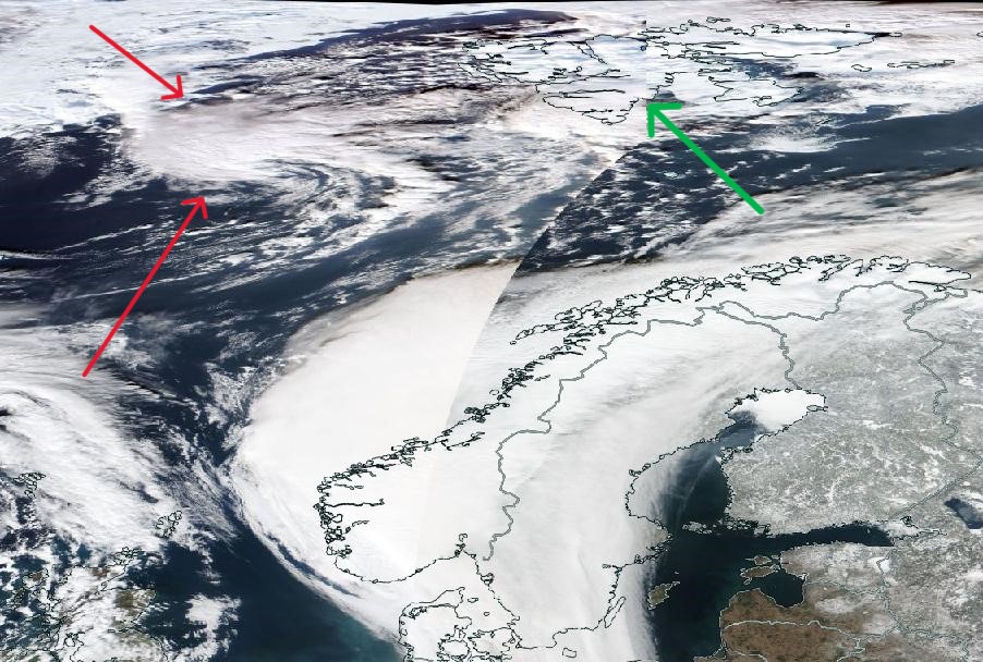
The polar low had at that point already formed. On the 16th of March, a relatively cold airmass moved over the open sea east of Iceland and in this cold airmass, a lot of convection took place and cumulonimbus clouds formed. The Cb’s clustered and while moving northeastward on the 16th and 17th of March, a polar low formed.
The satellite images from EUMETSAT show the polar low as it approaches Svalbard. Satellite images don’t get much more beautiful than this. A very clear eye is visible just before the polar low makes ‘landfall’.
Polar Low over Svalbard – Wind gusts up to 130 km/h!
In the evening, the sky started to look threathening in Longyearbyen. My partner and I went to our apartment to have some dinner. A bit after 20:00, it started snowing. But the snow fell in a fairly calm manner, with barely an wind present. I was quite surprised, because I expected wind, given the weather forecast and the fact that polar lows often cause intense winds. Nevertheless I was happy, as it started snowing quite intensively, finally bringing the much needed snow cover.
However, out of nothing, the calm snowfall transformed into a total white out. Extreme wind gusts in combination with the extreme snowfall decreased the visibility to less than 100 meters. We saw it happening from our apartment, but we went outside straight away to see and feel this extreme weather. At that point, I estimate the wind gusts were around 100 km/h (~28 m/s). We were not the only people going out; many of the visitors and students in the building went out and could not believe what was going on.
The winds kept picking up even more. The experience was extremely fascinating, exciting and even a bit scary. I can’t recall having felt such strong winds before. In combination with the snow – btw: snowflakes hurt, when they hit your face with speeds of more than 100 km/h – it was an attack on almost all senses of the body. At the peak, the wind even blew over a group of people, as you can see in the video below.
After this, it kept snowing and being windy for a while, however the wind speeds decreased quite rapidly. Only a few hours after, crystal clear skies were visible and alternated by some snow showers.
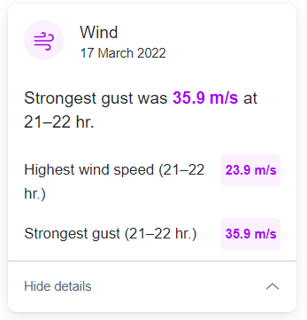
While still in disbelief over what just happened, I started gathering the videos that my partner Anna and I shot during the storm. I also collected some information on this weather event. Not too surprised, yet astonished, I noted down the extreme wind speeds that were measured. According the website of the Norwegian Meteorological Institute YR.no, Svalbard airport measured an hourly average wind speed of 23.9 m/s and a strongest gust of 35.9 m/s. Platåberget, the ~450 m high mountain plateau right next to Longyearbyen, measured an hourly average wind speed of 29.1 m/s and a strongest gust of 44.5 m/s. This is when the extremity of this weather event slowly started to get to me. In complete exitement I started compiling a video (see above).
The following day, I discussed this weather even with some other meteorologists at UNIS. Even for many of the people that have been living on Svalbard permanently (ranging from several years to over a decade), this was one of the most extreme weather events they have experienced at the archipelago. Extreme weather happens often on Svalbard, but polar lows almost never affect the archipelago. It is likely that they will start to occur more frequently, as the seas around Svalbard will be ice-free more frequently in the future due to climate change.
For me, this was one of the, if not THE wildest weather experiences ever. This blizzard is something I will never forget, surpassing all the other snow storms I have experienced in Svalbard, Finland, and, very rarely, The Netherlands. I have experienced one of the most fascinating weather phenomena out there, in real life.


